

This guide is a general introduction to the land grants of South Texas. It intended for students and new researchers seeking primary and secondary source materials on Cameron, Hidalgo, and Starr counties. It is not intended for genealogists and researchers seeking more comprehensive information on family lineage and descendancy.
Private land grants in South Texas did not begin until the mid-eighteenth century when colonists settled by José de Escandón in the province of Nuevo Santander sought individual land allocations. In 1767 a Spanish royal commission began surveying and granting possession along the Rio Grande in the villas of Laredo, Mier, Camargo, Revilla, and Reynosa.
They were followed by Mexican Land Grants (1810-1836) and Texas Land Grants, which began with the Republic's independence in 1836. By the 1850s, these various claims sparked conflicts among residents of the RGV, as lands conquered in wars were not claimed with consent of the landholders (learn more about the separatist movement). Texas Land Grants were patented by the state legislature when it confirmed the original grantees, and their heirs, Spanish or Mexican land grant titles. Therefore, heirs have both the genealogical and legal designation critical to land grant research.
There were 170 Spanish Land Grants, or porciones, in Texas. Porciones are elongated strips of land with a narrow segment along the Rio Grande to ensure each grantee had access to water for agricultural irrigation. Each porcion was assigned a number and were also named for colonists, saints, or the physical or natural characteristics of the area. The final commission and possession of each porcion was recorded in Acts of the Visit of the Royal Commissioners (Autos de la general visita) for the five villas.
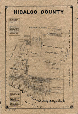
Photocopy of the original Hidalgo County 1848 porciones map.
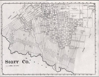
United States General Land Office, 1912.
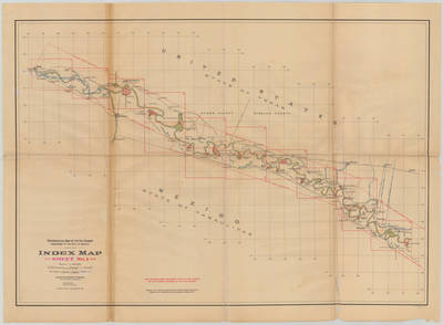
Cameron County, Texas General Land Office Map 1913 showing land patents, block and tract numbers, landowners, towns, and railroads; portions of adjacent counties where property boundaries extend beyond county limits. Scale not given.
[Texas]. General Land Office. Cameron County., map, 1913; Tulsa, Oklahoma. University of North Texas Libraries, The Portal to Texas History; crediting University of Texas at Arlington Library.

Featuring 363 expanded entries about Spanish and Mexican land grants in South Texas, this work is the new standard for this intriguing and sometimes controversial subject. The Guide includes a synoptic history of the issuance and confirmation of these grants, four appendices on related topics of interest, and details on mineral rights, patents, and other legal aspects of the tracts.

Select the county of interest and enter the name of the land grant patentee. For example, the document above is Cameron County, Garza, Jose S de la (patentee)
Julius Bien Co. Photo. Lith., Anson Mills. (1912). Banco map 89523. International Boundary & Water Commission, United States & Mexico.

An indispensable book for any researcher interested in Cameron County's history or land (or both), or its first landowners after Texas's Independence from Mexico. Each book in this series is laid out into multiple maps using a 6 mile high by 4 mile wide grid.
This book contains 65 Survey maps laid out within this grid. Each Land Survey Map shows the boundaries of original parcels laid out over existing roads, railroads, waterways. These are shown as well as the original Survey-Name and the Abstract Number assigned by the Texas General Land Office to the instrument that gave ownership to that parcel.

Centinela del Rio Grande. (Brownsville, Tex.), Vol. 1, No. 11, Ed. 1 Wednesday, March 13, 1850. Accessed via University of North Texas Libraries, The Portal to Texas History; crediting San Jacinto Museum of History.: https://texashistory.unt.edu/ark:/67531/metapth889208/m1/1/?q=american%20flag%20newspaper
Files include abstracts, correspondence, document packets and other legal documents, newspaper clippings, publications, and photographs. UTRGV Special Collections & Archives, Edinburg (ELIBR-0039).
The collection consists of business and personal files from John H. Shary, the largest collection of which is the United Irrigation Company series. The collection primarily contains business files, correspondence, internal memos, legal proceedings, maps, blueprints, and newspaper and magazine clippings. Majority of material found in 1912-1952. UTRGV Special Collections & Archives, Edinburg (ELIBR-0002).
Series IV: Real Estate - Documents, 1880-2000. Contains real estate documents pertaining to the history of ownership or ownership of land. Series 4.1 Abstracts of Title contains 27 boxes; Series 4.2 Document Packets contains 27 boxes of Deeds listed by number and name; Series 4.3 Other Document Packets contains 4 boxes of Deeds for Sharyland lots and miscellaneous northern properties; Series 4.4 Document Packets - Northern Properties contains 8 boxes of Deeds listed by name for properties located north of South Texas.
The papers of Menton Murray (1907-1989) consist of correspondence, photos, books, periodicals, speeches, awards and newspaper clippings. The papers document Murray’s careers as a journalist, lawyer, and Texas State Legislator. Additional activities include: Lion’s Club, Knights of Columbus, Harlingen Cardinal’s Quarterback Club, the Cameron County Historical Society and many more. The collection contains information on Murray’s World War II service and his personal life. The collection includes abstracts of titles for the Brownsville and Harlingen townsites, as well as other legal documentation for land transactions and porciones. UTRGV Special Collections & Archives, Brownsville (BLIBR-0015).
Students registered for the CHAPS course, "Discovering the Rio Grande Valley: The Natural and Cultural History of South Texas," experience a combination of classroom and “field” activities. The main project consists of research on a given family and its property, including field research activities like oral history, archeological research, land ownership/title, GIS mapping, and biological research. Their contribution culminates in a published porciones report.


 Francis William Seabury Papers, 1714-1946
Letters, genealogies, abstracts of title, affidavits, appeals, attachments, bills of sale, bonds, briefs, checks, contracts, deeds, insurance policies, leases, mortgages, opinions, summons, wills, notes, maps, and broadsides comprise the Francis William Seabury Papers (1714-1946), which document Seabury's career as an attorney and legislator. The papers consist of correspondence and case records relating to various litigations, during Seabury's career. Furthermore, the papers contain genealogical information, Seabury's personal papers, and personal correspondence.
Repository: Dolph Briscoe Center for American History, The University of Texas at Austin
The research guides compiled by UTRGV staff and students are intended to assist patrons who are embarking upon new research endeavors. Our goal is to expand their knowledge of the types of resources available on a given topic, including books, archival materials, and websites. In so doing, our compilers have taken care to include collections, digital items, and resources that may be accessed not only through UTRGV but also via other institutions, repositories, and websites.
We wholeheartedly respect the research interests of others. Therefore, please contact us if you wish to submit a resource for consideration, or if you have a question about or an issue with a specific cited resource.
 El Rancho in South Texas
by
This book discusses the history of ranching in South Texas, illustrated with photographs that were part of "the first major exhibit to examine the private cattle ranch in South Texas, held in 1994 in the John E. Connor Museum in Kingsville, Texas" (p. ix). Index starts on page 117.
This book is also accessible online via UNT Portal to Texas history https://texashistory.unt.edu/ark:/67531/metadc28328/
El Rancho in South Texas
by
This book discusses the history of ranching in South Texas, illustrated with photographs that were part of "the first major exhibit to examine the private cattle ranch in South Texas, held in 1994 in the John E. Connor Museum in Kingsville, Texas" (p. ix). Index starts on page 117.
This book is also accessible online via UNT Portal to Texas history https://texashistory.unt.edu/ark:/67531/metadc28328/
 From porciones to colonias: the power of place - and community - based learning in K-12 education - a case study from the Lower Rio Grande Valley of Texas = De la porciones a las colonias: la fuerza del aprendizaje con enfoque local y comunitario dentro d
by
From Porciones to Colonias: The Power of Place- and Community-Based Learning in K-12 Education redefines culturally relevant learning in today’s diverse classroom. By integrating an interdisciplinary approach including: anthropology, archeology, biology, geology, and history the CHAPS Program presents an effective method in supporting teachers of the Rio Grande Valley in creating culturally relevant curriculum, while meeting the demands of state and federal mandates.
New guide to Spanish and Mexican land grants in south Texas
by
Featuring 363 expanded entries about Spanish and Mexican land grants in South Texas, this work is the new standard for this intriguing and sometimes controversial subject. The Guide includes a synoptic history of the issuance and confirmation of these grants, four appendices on related topics of interest, and details on mineral rights, patents, and other legal aspects of the tracts.
From porciones to colonias: the power of place - and community - based learning in K-12 education - a case study from the Lower Rio Grande Valley of Texas = De la porciones a las colonias: la fuerza del aprendizaje con enfoque local y comunitario dentro d
by
From Porciones to Colonias: The Power of Place- and Community-Based Learning in K-12 Education redefines culturally relevant learning in today’s diverse classroom. By integrating an interdisciplinary approach including: anthropology, archeology, biology, geology, and history the CHAPS Program presents an effective method in supporting teachers of the Rio Grande Valley in creating culturally relevant curriculum, while meeting the demands of state and federal mandates.
New guide to Spanish and Mexican land grants in south Texas
by
Featuring 363 expanded entries about Spanish and Mexican land grants in South Texas, this work is the new standard for this intriguing and sometimes controversial subject. The Guide includes a synoptic history of the issuance and confirmation of these grants, four appendices on related topics of interest, and details on mineral rights, patents, and other legal aspects of the tracts.
 Tejano Legacy
by
This is a pathbreaking study of Tejano ranchers and settlers in the Lower Río Grande Valley from their colonial roots to 1900. The first book to delineate and assess the complexity of Mexican-Anglo interaction in south Texas, it also shows how Tejanos continued to play a leading role in the commercialization of ranching after 1848 and how they maintained a sense of community. Despite shifts in jurisdiction, the tradition of Tejano land holding acted as a stabilizing element and formed an important part of Tejano history and identity. The earliest settlers arrived in the 1730s and established numerous ranchos and six towns along the river. Through a careful study of land and tax records, brands and bills of sale of livestock, wills, population and agricultural censuses, and oral histories, Alonzo shows how Tejanos adapted to change and maintained control of their ranchos through the 1880s, when Anglo encroachment and changing social and economic conditions eroded most of the community's land base.
Tejano Legacy
by
This is a pathbreaking study of Tejano ranchers and settlers in the Lower Río Grande Valley from their colonial roots to 1900. The first book to delineate and assess the complexity of Mexican-Anglo interaction in south Texas, it also shows how Tejanos continued to play a leading role in the commercialization of ranching after 1848 and how they maintained a sense of community. Despite shifts in jurisdiction, the tradition of Tejano land holding acted as a stabilizing element and formed an important part of Tejano history and identity. The earliest settlers arrived in the 1730s and established numerous ranchos and six towns along the river. Through a careful study of land and tax records, brands and bills of sale of livestock, wills, population and agricultural censuses, and oral histories, Alonzo shows how Tejanos adapted to change and maintained control of their ranchos through the 1880s, when Anglo encroachment and changing social and economic conditions eroded most of the community's land base.
This collection started with the work of borderlands historian, Dr. Sonia Hernandez, who oversaw student research on porciones, or Spanish land grants. This research begins with life histories of local families and traces their land acquisition to first European contact in the borderlands. Following the course of approximately 300 years of change, the histories specify the shifts that large tracts of property underwent as evidenced by the official records of land title and warranty deeds, official family trees, maps, photos, oral histories and letters.
This collection is part of a larger project devoted to documenting Borderlands history developed with the Community Historical Archaeology Project with Schools (CHAPS).
Appointments are recommended for most new researchers. Our team is available in Brownsville and Edinburg to assist you with identifying resources.